


Science at work 15 July 2026

Undergrowth in the Mare Longue forest, La Réunion National Park © A. Franck, CIRAD
Réunion is a biodiversity “hotspot”, in other words a place with a rich biodiversity that is threatened by human activities. But the island also has 129 invasive alien species, making it one of the ten most invaded territories in the world. To protect local biodiversity, the island is supported by its protected area managers, including those from Réunion National Park and the Office Nationale des Forêts (ONF - National Forestry Office), but also by research institutes. However, until recently, each structure used its own field survey methods, making it difficult to coordinate control actions.
“Everyone had their own method to assess the level of invasion”, says Pauline Fenouillas, an ecologist at CIRAD. “This meant we were then unable to compare data, and to thus effectively discuss priority areas. We needed to develop a standardised protocol that can be used rapidly in the field, and which enables us to homogenise the results and to make decisions based on a shared assessment”.
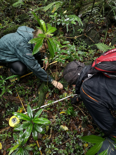
Field inventory in the Mare Longue forest by a Réunion National Park - CIRAD team © P. Fenouillas, CIRAD
The method was developed by CIRAD and the University of Réunion, in consultation with Réunion National Park and the different managers on the island. It is based on two key principles. First, observing two categories: indigenous plant species and exotic plant species. “During a field survey, it is impossible to conduct a full botanical survey unless you have the time and human resources needed”, says Mathieu Rouget, an ecologist at CIRAD. “By simplifying the process into two categories, we can rapidly measure the balance of power between indigenous and exotic species”.
Second, managers need to make this observation across three vegetation layers: herbs, shrubs and trees. This distinction is important because plant renewal times vary significantly across these three layers. In forests, for example, it takes trees in the tree layer around 50 years to reach the canopy. Pauline Fenouillas explains: “a forest whose herb layer has been invaded will be easier to restore than a forest whose other layers are invaded, since plant renewal is rapid there. Observing ground cover is nevertheless crucial. If the herb layer is completely invaded but nothing is done because the forest seems healthy, there is a risk that all indigenous species will disappear within 50 years”.
This new field survey has been tested by managers and is now included in their routine. During the initial study in 2019, several hundred hectares were closely analysed. Today, the National Park is launching major survey campaigns across thousands of hectares.

Mapping the degree of invasion by exotic species in the Mare Longue forest © CIRAD
This new method is the result of several years of work on measuring the degree of invasion in Réunion, which was previously done at the island level using modelling tools. “Switching from an IT tool to a field tool was a real challenge”, says Pauline Fenouillas. “Thanks to our partnerships with managers, including ONF and the National Park, we have been able to create an effective, useful protocol that can be adapted to the different forest areas”.
The next step, after the full survey, will be to prioritise the areas for invasion management. This is one of the objectives of the ReMiNat project (Restoration of natural areas), which began in autumn 2023. Financed by the French government’s Green Fund, the ReMiNat project brings together all of the stakeholders working to preserve biodiversity in Réunion. The main challenges are the preservation and restoration of natural habitats.
“It is important that we succeed in prioritising high-risk areas and then implementing coordinated actions”, says Pauline Fenouillas. “Finally, we will need to assess decisions according to results in the field, in order to adjust and improve our work to ensure it remains useful for the management of natural areas”.
Fenouillas, P., Caubit, M., Cazal, E., Ajaguin Soleyen, C., Strasberg, D., Rouget, M. 2024. Standardising field-based assessment of invasion degree: A case study in two habitats of Reunion Island. Ecological Solutions and Evidence, 5 (1): e12314.
Science at work 15 July 2026
Science at work 1 July 2026
Science at work 23 June 2026